
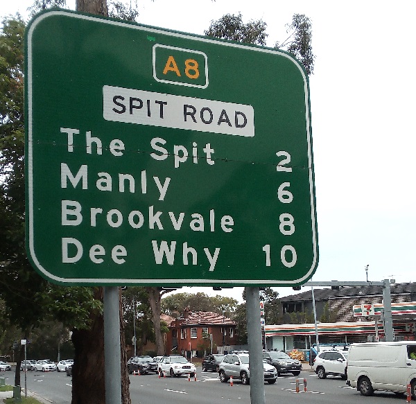
I love this sign:
I think that it's fair to say that every single sign in the history of the world is designed to convey at least one unit of information. I would go further that that an suggest that every single piece of writing and every single piece of communication is designed to convey at least one unit of information. Even a piece of graffiti, sprayed on the side of a wall or train, conveys the unit of information that 'Soups', 'Wako', 'Huek' and 'Gedup' have been somewhere.
A sign like this, not only conveys a unit of information about distance but also a unit of information about what is considered to be valuable and useful to know. The former is a matter of fact; the latter is the result of a value judgement, which contains a whole constellation of unsaid assumptions about how the world works.
The modern world as we know, only really began to take shape after the invention of three key pieces of technology. The first piece of tech is potable clean water being piped into people's houses. That is basically the reason why people tend not to die of a host of water borne diseases like cholera before the age of 10. The second piece of tech is electricity. Electricity absolutely transformed the insides of people's houses, the entire of industry, and even how transport systems work. The third piece of tech is the internal combustion engine; which not only pushed the development of the motor car but trucking and logistics and the necessary infrastructure to go along with it.
Roads existed well before the invention of the motor car and motor truck but the advent of modern highway systems has enabled goods and services to flash around countries and the world, at rates never before seen. This is the reason why I can have a lovely piece of steak for dinner which comes from southern Queensland. One hundred years ago, before the invention of refrigeration and trucking, that would have been simply impossible.
I think that it's fair to say that road networks are driven more from an economic standpoint rather than a desire by governments to provide a public service. Governments want a return on their investment; which is why I suspect that in my state of New South Wales, they're more likely to want to build a toll road because of a desire to extract tolls out of motorists and even more so trucking and freight, than actually provide a service to the good and fair people of New South Wales.
The laying out of modern road infrastructure also necessitated more exact information systems. Whereas once signs used to be provided by parishes, villages, local towns, and counties, they are now mostly provided by the state. That also warranted a change from where towns' mileage markers are measured from. The City Of Sydney, which used to be the township of Sydney, has an obelisk way way closer to the harbour than you might expect and it is from that point that all roads in New South Wales officially draw their mileage from; and not the General Post Office as is the case in practically every other state in the Commonwealth.
The usual point from which mileage is laid out (I am a Metric Man, every inch of the way) is from the Post Office that defines the locality. Notice how I use the word 'locality'. Postcodes are things drawn by Australia Post and usually coincide with Suburbs but they do not have to. Localities are places within suburbs that are usually defined by Post Office.
I live in Marayong which has the postcode of 2148. This is a notoriously large postcode which also encompasses places like Blacktown, Arndell Park and Prospect. Across the postal boundary in 2147, we have the suburbs of Seven Hills, Kings Langley and Lalor Park. There is also the unoffcial locality of Grantham Heights; which real estate agents want to put in advertisements but which doesn't actually exist. Marayong has a post office. Blacktown has a very big post office. Seven Hills, Kings Langley and Lalor Park all have their own post offices. In all cases as far I as I can tell, the official measurement of where roads are measured from is those post offices.
I work in the suburb of Mosman and even the people who live there have to concede that Mosman Municipal Council is a weird weird thing. Officially it is one suburb and one postcode (2088). When the NSW State Government threatened to merge it with North Sydney Council, Mosman Municipal Council ran a leaflet campaign telling everyone that they would split the suburb into 5, just so the local government area would somehow look more powerful than it is.
Balmoral Beach is not a suburb but a physical place. Taronga is the name of the zoo but isn't even a locality. Spit Junction and Mosman Junction aren't suburbs but the names of the post offices serving the postcode 2088 which only contains the suburb of Mosman.
The Spit is a landmark like Balmoral Beach is but the businesses and even the addresses on the marina have a Mosman 2088 postal address just like they do at Balmoral Beach. It is one of the oddest landmarks to list on a road sign though because unlike Balmoral Beach, Spit Road continues to head north over Spit Bridge and across Middle Harbour. You can get to The Spit on Spit Road but if you have actually got there, then you can not get out because you will be doing 60km/h.
The Spit is also different to the other three things listed on the road sign. The Spit is a landmark. The Spit is not a suburb. There are no addresses with The Spit as their location. Spit Junction Post Office is not in the suburb of The Spit. You can not even send mail to an Post Office Box listed as Spit Junction because they are all listed as being in Mosman; which they are. Manly, Brookvale, and Dee Why are all suburbs and because they are suburbs as previously stated, they will have their mileage measured from the Post Office. For The Spit though, if you see this sign, you will have already passed the relevant post office from where the distances are measured from.
This isn't unique when it comes to Sydney's road signs either. In this part of the world, you will see signs directing you to City; which is also not a suburb but a vague concept which isn't even defined as to where it is. You will also find signs directing you to Harbour Bridge and Harbour Tunnel; which are physical things but due to the nature of them crossing the harbour, I have no idea whether or not they are actually in any suburb at all.
Of course, these kinds of things are different to cultural destinations such as Taronga Zoo, Sydney Cricket Ground, and Opera House, and they usually appear on brown signs as opposed to the usual green ones.
The existence of The Spit on a road sign is not unexpected because it is an obvious thing to measure distance from but it is unusual. What's more, it is also useful. The Spit Bridge is one of those traffic bottlenecks which twice a day opens; and no motor traffic can pass. If you are a motorist and/or a truck driver, that's a really handy piece of information to have at your disposal as this sign with 2km marked upon it, is almost but not quite the point of no return. You can turn around and head back around via Chatswood and the Roseville Bridge but once you get past a certain point, there are no other roads that you can go, to head north.
That's a lot of work that the number 2 is doing in this sign. Manly, Brookvale and Dee Why are all sensible destinations in their own right. Manly has beaches, Brookvale has a football stadium, Dee Why serves as a fairly important suburban hub. The Spit isn't really any of those things. It isn't really a destination for motorists unless you really want to get out and visit the little park, the little beach and the few seaside restaurants. No, this sign is telling you that this is where the North Shore ends. Beyond 2km, there be sea monsters, bunyips, goblins and hobgoblins. This is your last warning. Turn around, save yourself, or keep going and cross over The Spit Bridge to... well actually to the rest of suburbia.
No comments:
Post a Comment